Geological Survey initiative seeks to create an updated seismic hazard map for Puerto Rico
Submitted on 14 July 2023 - 12:32pm
This article is reproduced by CienciaPR with permission from the original source.
CienciaPR Contribution:
Original Source:
The study began in February and has since been dedicated to conducting the first high-resolution airborne magnetic and radiometric studies over the island and its surrounding waters.
A series of studies supported by more than $1 million in funding from the U.S. Geological Survey (USGS) will map the local geology and update the seismic hazard map of Puerto Rico, which has not been updated in 20 years.
This effort was announced by the USGS last February, and since then it has been conducting the first high-resolution airborne magnetic and radiometric studies over the archipelago and its surrounding waters.
"Updating the seismic hazard map means knowing in detail where the fault begins and where it ends, knowing exactly what the geometry of the fault is, knowing what the generation potential of that fault is and, above all, what its recurrence is (average time between the occurrence of seismic events on a fault or a given tectonic region)," said Víctor Huérfano, director of the Puerto Rico Seismic Network.
The last update occurred in 2003, according to the USGS website. In the map, which also serves as a reference for the seismic criteria of the Puerto Rico Building Code, only the fault identified inland in the Lajas Valley area appears, which is a "great concern" for the scientific community, said the physical oceanographer in a press release.
The last update occurred in 2003, according to the USGS website. In the map, which serves as a reference for the seismic criteria of the Puerto Rico Building Code, the only identified inland fault is in the Lajas Valley area , which is a "great concern" for the scientific community, the physical oceanographer commented in an interview with El Nuevo Día.
"Neither the Guánica (fault), nor the Punta Montalva fault, nor the Ponce fault (appear on the map). Some people say that there is a fault that starts in Rincón and may even reach as far as Salinas, which is the Great Southern Fault Zone of Puerto Rico... other scientists have seen something over there by Guayama. But to say, 'it seems to me that there is a fault,' is not very helpful. To be able to put it on the map, I have to be specific, to know where it starts, to know where it ends, that is fundamental," he said.
:format(jpeg)/cloudfront-us-east-1.images.arcpublishing.com/gfrmedia/CMXCAI3NQBG3JF4TVOQYZBCY3Q.jpg)
Huérfano added that the seismic hazard map must be updated by 2025, as mandated by the U.S. Congress. The USGS data to complete this process could be available by the end of this year, he said.
Funding for the collection of this data comes from the Joe Biden administration's Bipartisan Infrastructure Act, which has allocated more than $320 million in funding for geologic studies driven by the USGS's Earth Mineral Resources Initiative ("Earth MRI"). The federal agency's Earthquake Hazards Program and the Coastal and Marine Hazards and Resources Program provided additional funding for the airborne survey of Puerto Rico, according to a statement.
The data collection - which began in February and lasted until this month - will allow scientists from the USGS, the University of Puerto Rico (UPR) Mayagüez Campus (RUM) and other groups to evaluate the geological hazards that the archipelago could suffer, such as earthquakes and landslides.
Huérfano explained that the multiple flights made by a Canadian plane -from west to east in "north-south and south-north lines"- began in February and lasted until the middle of this month. Now, the researchers are assessing whether the data was collected correctly - a process that should take several weeks - to complete the measurement and begin lab work.
:format(jpeg)/cloudfront-us-east-1.images.arcpublishing.com/gfrmedia/M3BG4I3S7ZAHNNRE5I62WUWVL4.jpg)
"(The plane's sensors) are detecting what the rocks are emitting to know what kind of geology is there," he explained. "The main objective is to have a more recent and much higher resolution geological image of both geology and magnetism, since they are related. That is, when I say geology I also mean the type of rock, and that is measured by its magnetic component."
According to the USGS, the airborne geophysical survey is the first of its kind for Puerto Rico. The last "low-resolution" airborne geophysical data was collected in studies of small sections of the island in 1957 and 1962. In addition, no airborne radiometric survey had ever been flown over Puerto Rico.
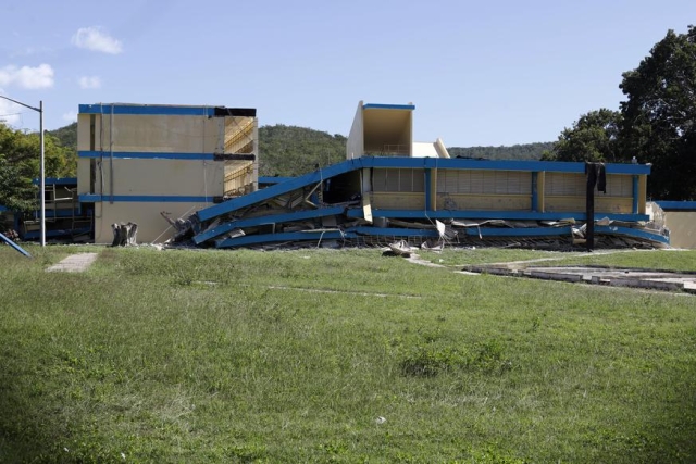
"In the long run, the objective is for the infrastructure to resist these types of movements, which is what happened in Guánica (with the January 2020 earthquakes), when the school fell and houses fell. So, what we are pursuing with all this work is to be able to leave an updated map so that engineers, contractors, builders or architects have an idea of what they have to design to resist what. Because they are hardly going to be able to make a seismic-resistant design when they do not know which is the earthquake they have to face", added Huérfano.