DRNA and the Caribbean Regional Oceanic Alliance present new tool for planning and managing marine spaces
Submitted on 18 July 2015 - 11:24am
This article is reproduced by CienciaPR with permission from the original source.
CienciaPR Contribution:
Original Source:
By:
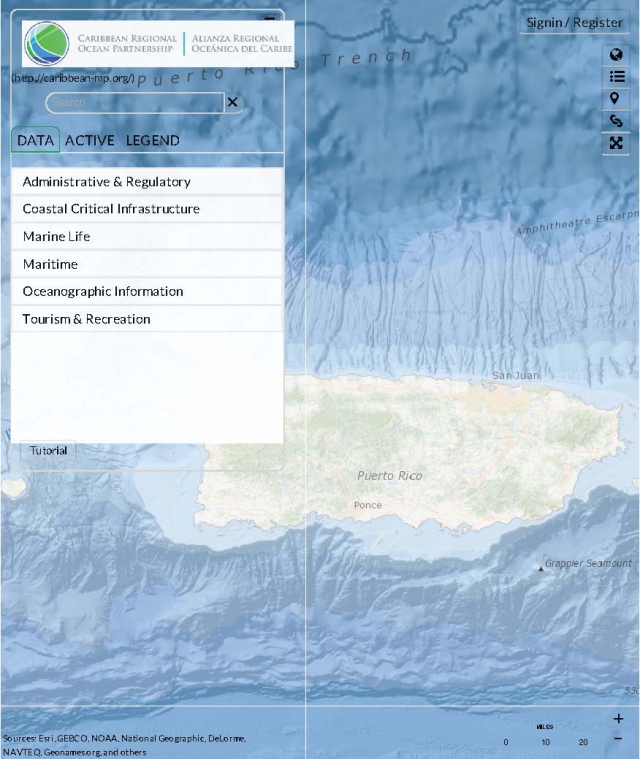
Marine Planner is a dynamic online tool to engage stakeholders in ocean planning in the U.S. Caribbean Islands region. Marine Planner consolidates essential data onto a state of the art mapping and visualization platform that allows state, federal, and local users to visualize, query, map, and analyze ocean and coastal data. By placing these resources directly in the hands of regional ocean stakeholders, the Ocean Planner supports collaborative decision making and robust regional ocean planning.
Marine Planner leverages the flexibility of the OpenLayers mapping library providing users with an intuitive and cartographically pleasing user experience. We have chosen the ESRI Ocean Basemap for its muted color palette, serving as an ideal background for the dozens of data layers that are displayed on the site.
The data layers themselves have been sourced from a variety of public agencies. Some have been modified to improve their styling, while others have been generated specifically for the CROP mapping and planning process.
While Marine Planner serves the use of a stand-alone data viewer, its full potential lies in its use as a collaborative decision support tool. Map views can be shared at any time between authenticated and non-authenticated users alike via built-in email and Twitter links. To encourage collaboration in the decision and planning processes, user-generated design features can also be shared with other authenticated users through the tool’s built-in sharing functionalities.
###
Contactos:
Carmen Milagros Díaz
787-344-4701
cmdiaz@drna.gobierno.pr
comunicacionesdrna@gmail.com
Maricelis Rivera Santos
787-615-2876
maricelis.riverasantos@gmail.com